The John Muir Way
A 134-mile walking trail that passes by the Forth & Clyde Canal in Falkirk.
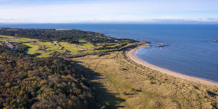
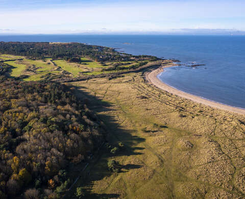
The John Muir Way offers outdoor enthusiasts a chance to explore Scotland's diverse natural beauty, including stunning coastlines, picturesque countryside, and historical sites. The route takes you through a variety of terrains, from coastal paths to woodlands, providing a unique experience for walkers and cyclists alike.
The route is named after the Dunbar-born conservationist John Muir, who emigrated to America whilst still a boy and became the father of the American National Parks and a key figure in the conservation movement; it opened in 2014 to commemorate the 100th anniversary of Muir's death.
The route reverses Muir's steps from Helensburgh on the west coast - from where he boarded ship and set sail for America - back to his birthplace, Dunbar in East Lothian. It begins with a walk over the hills to reach the fabulous landscapes of Loch Lomond. It then follows old minor roads and disused railway lines to traverse the rural, farming landscapes in the shadow of the Campsie Fells. Eventually it picks up the route of the Forth and Clyde canal, following the towpath through the mix of industrial and urban landscapes at heart of Scotland with occasional diversions from the water to visit significant sites along the Antonine Wall. After the ancient town of Linlithgow it strikes north to reach the Forth at Bo'ness, and then follows this along the coast beneath the Forth Bridge and on to Edinburgh. It passes through the fringes of Scotland's capital before returning to the coastline as it heads into the more rural landscapes of East Lothian, before finally ending at Muir's birthplace, Dunbar.
Useful information
Accessibility info
We aim to make the route as accessible to as many people as possible. Much of it follows smoothly surfaced paths – disused railways, canal towpaths and cycleways – but some sections are steeper, narrower and rougher, may include busy road crossings or may present obstacles such as narrow gates or steps.
For the most physically challenging sections, an alternative option is waymarked with a cycle symbol where it branches off from the main route. This alternative option is also usually (but not always) more accessible with a buggy, wheelchair or horse.
To help you assess for yourself which sections are suitable for your intended use, level of fitness and physical mobility, the John Muir Way was surveyed in autumn 2021 and a series of storymaps produced providing details, locations and photos of features which may restrict accessibility of the waymarked John Muir Way (both the main 'walking' route and alternative 'cycle' route sections). The storymaps are equally relevant to walkers, cyclists, horse riders, people using mobility aids, wheelchairs or pushing buggies.
Food and drink
There are food and drink options available along the John Muir Way, particularly in towns and villages along the route. Visitors can enjoy a variety of dining experiences, including cafes, restaurants, and pubs.
Visitors centre
The John Muir Way does not have a specific visitor center. It is recommended to consult the trail's official website to obtain information.
Dogs
Dogs are allowed but should be kept on a lead and under control at all times.